POWER PLANT ENGINEERING (UNIT-3)
UNIT-3
HYDRO ELECTRIC POWER PLANT: Water power – hydro-logical cycle / flow measurement – drainage area characteristics - hydro graphs - storage and pondage - classification of dams and spill ways.
HYDRO PROJECTS AND PLANT: Classification – typical layouts – plant auxiliaries – plant operation pumped storage plants.
Introduction to Water Power:
Hydro power or water power (from Greek) is power derived from the energy of falling water or fast running water, which may be harnessed for useful purposes. Since ancient times, hydro power from many kinds of watermills has been used as a renewable energy source for irrigation and the operation of various mechanical devices, such as gristmills, sawmills, textile mills, trip hammers, dock cranes, domestic lifts, and ore mills. A tromp, which produces compressed air from falling water, is sometimes used to power other machinery at a distance.
Hydro Cycle / Water Cycle / Hydro-logical Cycle:
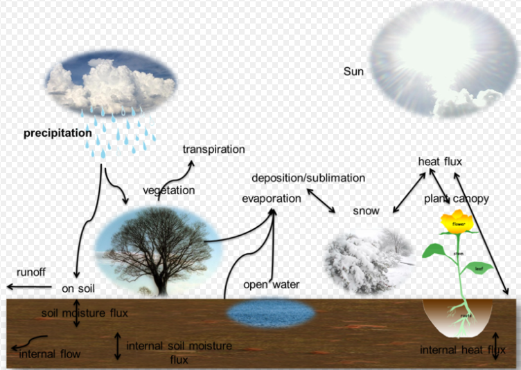
- The sun, which drives the water cycle, heats water in oceans and seas. Water evaporates as water vapor into the air. Some ice and snow sublimates directly into water vapor.
- Evapo-transpiration is water transpired from plants and evaporated from the soil. The water molecule H₂O has smaller molecular mass than the major components of the atmosphere, nitrogen and oxygen, N₂ and O₂, hence is less dense.
- Due to the significant difference in density, buoyancy drives humid air higher. As altitude increases, air pressure decreases and the temperature drops (see Gas laws).
- The lower temperature causes water vapor to condense into tiny liquid water droplets which are heavier than the air, and fall unless supported by an updraft. A huge concentration of these droplets over a large space up in the atmosphere become visible as cloud.
- Some condensation is near ground level, and called fog. Atmospheric circulation moves water vapor around the globe, cloud particles collide, grow, and fall out of the upper atmospheric layers as precipitation. Some precipitation falls as snow or hail, sleet, and can accumulate as ice caps and glaciers, which can store frozen water for thousands of years. Most water falls back into the oceans or onto land as rain, where the water flows over the ground as surface runoff.
- A portion of runoff enters rivers in valleys in the landscape, with stream flow moving water towards the oceans. Runoff and water emerging from the ground (groundwater) may be stored as freshwater in lakes. Not all runoff flows into rivers, much of it soaks into the ground as infiltration. Some water infiltrates deep into the ground and replenishes aquifers, which can store freshwater for long periods of time.
- Some infiltration stays close to the land surface and can seep back into surface-water bodies (and the ocean) as groundwater discharge.
- Some groundwater finds openings in the land surface and comes out as freshwater springs. In river valleys and floodplains, there is often continuous water exchange between surface water and ground water in the hyporheic zone. Over time, the water returns to the ocean, to continue the water cycle.
Processes:
Precipitation
Condensed water vapor that falls to the Earth's surface. Most precipitation occurs as rain, but also includes snow, hail, fog drip, graupel, and sleet.
Canopy interception
The precipitation that is intercepted by plant foliage eventually evaporates back to the atmosphere rather than falling to the ground.
Snow melt
The runoff produced by melting snow.
Runoff
The variety of ways by which water moves across the land. This includes both surface runoff and channel runoff. As it flows, the water may seep into the ground, evaporate into the air, become stored in lakes or reservoirs, or be extracted for agricultural or other human uses.
Infiltration
The flow of water from the ground surface into the ground. Once infiltrated, the water becomes soil moisture or groundwater.A recent global study using water stable isotopes, however, shows that not all soil moisture is equally available for groundwater recharge or for plant transpiration.
Subsurface flow
The flow of water underground, in the vadose zone and aquifers. Subsurface water may return to the surface (e.g. as a spring or by being pumped) or eventually seep into the oceans. Water returns to the land surface at lower elevation than where it infiltrated, under the force of gravity or gravity induced pressures. Groundwater tends to move slowly and is replenished slowly, so it can remain in aquifers for thousands of years.
Evaporation
The transformation of water from liquid to gas phases as it moves from the ground or bodies of water into the overlying atmosphere.The source of energy for evaporation is primarily solar radiation. Evaporation often implicitly includes transpiration from plants, though together they are specifically referred to as evapotranspiration.
Sublimation
The state change directly from solid water (snow or ice) to water vapor by passing the liquid state.
Deposition
This refers to changing of water vapor directly to ice.
Advection
The movement of water through the atmosphere.Without advection, water that evaporated over the oceans could not precipitate over land.
Condensation
The transformation of water vapor to liquid water droplets in the air, creating clouds and fog.
Transpiration
The release of water vapor from plants and soil into the air.
Percolation
Water flows vertically through the soil and rocks under the influence of gravity.
Plate tectonics
Water enters the mantle via subduction of oceanic crust. Water returns to the surface via volcanism.
The water cycle involves many of these processes.
Scales for study of hydrologic cycle:
From the point of view of hydrologic studies, two scales are readily distinct. These are the global scale and the catchment scale.
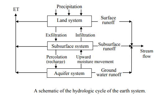
Global scale From a global perspective, the hydrologic cycle can be considered to be comprised of three major systems; the oceans, the atmosphere, and the landsphere. Precipitation, runoff and evaporation are the principal processes that transmit water from one system to the other. This illustration depicts a global geophysical view of the hydrologic cycle and shows the interactions between the earth (lithosphere), the oceans (hydrosphere), and the atmosphere. The study at the global scale is necessary to understand the global fluxes and global circulation patterns. The results of these studies form important inputs to water resources planning for a national, regional water resources assessment, weather forecasting, and study of climate changes. These results may also form the boundary conditions of small-scale models/applications.


Catchment Scale
While studying the hydrologic cycle on a catchment scale, the spatial coverage can range from a few square km to thousands of square km. The time scale could be a storm lasting for a few hours to a study spanning many years. When the water movement of the earth system is considered, three systems can be recognized: the land (surface) system, the subsurface system, and the aquifer (or geologic) system. When the attention is focused on the hydrologic cycle of the land system, the dominant processes are precipitation, evapotranspiration, infiltration, and surface runoff. The land system itself comprises of three subsystems: vegetation subsystem, structural subsystem and soil subsystem. These subsystems subtract water from precipitation through interception, depression and detention storage. This water is either lost to the atmospheric system or enters subsurface system. The exchange of water among these subsystems takes place through the processes of infiltration, exfiltration, percolation, and capillary rise.
Timescales in the hydrologic cycle
The time required for the movement of water through various components of the hydrologic cycle varies considerably. The velocity of stream flow is much higher compared to the velocity of groundwater. The time-step size for analysis depends upon the purpose of the study, the availability of data, and how detailed the study is. The estimated periods of renewal of water resources in water bodies on the earth is given in Table.T he time step should be sufficiently small so that the variations in the processes can be captured in sufficient detail but at the same time, it should not put an undue burden on data collection and computational efforts.

Topography
Generally, topography plays a big part in how fast runoff will reach a river. The rain that falls in steep mountainous areas will reach the primary river in the drainage basin faster than flat or lightly sloping areas (e.g., > 1% gradient).
Shape
The shape will contribute to the speed with which the runoff reaches a river. A long thin catchment will take longer to drain than a circular catchment.
Size
Size will help determine the amount of water reaching the river, as the larger the catchment the greater the potential for flooding. It is also determined on the basis of length and width of the drainage basin.
Soil type
Soil type will help determine how much water reaches the river. Certain soil types such as sandy soils are very free-draining, and rainfall on sandy soil is likely to be absorbed by the ground. However, soils containing clay can be almost impermeable and therefore rainfall on clay soils will run off and contribute to flooding volumes. After prolonged rainfall even free-draining soils can become saturated, meaning that any further rainfall will reach the river rather than being absorbed by the ground. If the surface is impermeable the precipitation will create surface run-off which will lead to higher risk of flooding; if the ground is permeable, the precipitation will infiltrate the soil.
Land use
Land use can contribute to the volume of water reaching the river, in a similar way to clay soils. For example, rainfall on roofs, pavements, and roads will be collected by rivers with almost no absorption into the groundwater.
Classification of Dams & Spillways:


Scales for study of hydrologic cycle:
From the point of view of hydrologic studies, two scales are readily distinct. These are the global scale and the catchment scale.
Global scale From a global perspective, the hydrologic cycle can be considered to be comprised of three major systems; the oceans, the atmosphere, and the landsphere. Precipitation, runoff and evaporation are the principal processes that transmit water from one system to the other. This illustration depicts a global geophysical view of the hydrologic cycle and shows the interactions between the earth (lithosphere), the oceans (hydrosphere), and the atmosphere. The study at the global scale is necessary to understand the global fluxes and global circulation patterns. The results of these studies form important inputs to water resources planning for a national, regional water resources assessment, weather forecasting, and study of climate changes. These results may also form the boundary conditions of small-scale models/applications.
Catchment Scale
While studying the hydrologic cycle on a catchment scale, the spatial coverage can range from a few square km to thousands of square km. The time scale could be a storm lasting for a few hours to a study spanning many years. When the water movement of the earth system is considered, three systems can be recognized: the land (surface) system, the subsurface system, and the aquifer (or geologic) system. When the attention is focused on the hydrologic cycle of the land system, the dominant processes are precipitation, evapotranspiration, infiltration, and surface runoff. The land system itself comprises of three subsystems: vegetation subsystem, structural subsystem and soil subsystem. These subsystems subtract water from precipitation through interception, depression and detention storage. This water is either lost to the atmospheric system or enters subsurface system. The exchange of water among these subsystems takes place through the processes of infiltration, exfiltration, percolation, and capillary rise.
Timescales in the hydrologic cycle
The time required for the movement of water through various components of the hydrologic cycle varies considerably. The velocity of stream flow is much higher compared to the velocity of groundwater. The time-step size for analysis depends upon the purpose of the study, the availability of data, and how detailed the study is. The estimated periods of renewal of water resources in water bodies on the earth is given in Table.T he time step should be sufficiently small so that the variations in the processes can be captured in sufficient detail but at the same time, it should not put an undue burden on data collection and computational efforts.
Drainage Area Characteristics:
- A drainage basin is an area of land where precipitation collects and drains off into a common outlet, such as into a river, bay, or another body of water.
- The drainage basin includes all the surface water from rain runoff, snowmelt, and nearby streams that run downslope towards the shared outlet, as well as the groundwater underneath the earth's surface.
- Drainage basins connect into other drainage basins at lower elevations in a hierarchical pattern, with smaller sub-drainage basins, which in turn drain into another common outlet.
- Other terms used interchangeably with drainage basin are catchment area, catchment basin, drainage area, river basin, and water basin.
- In North America, the term watershed is commonly used to mean a drainage basin, though in other English-speaking countries, it is used only in its original sense, that of a drainage divide.
- In a closed drainage basin or endorheic basin, the water converges to a single point inside the basin, known as a sink, which may be a permanent lake, a dry lake, or a point where surface water is lost underground.
- The drainage basin acts as a funnel by collecting all the water within the area covered by the basin and channeling it to a single point.
- Each drainage basin is separated topographically from adjacent basins by a perimeter, the drainage divide, making up a succession of higher geographical features (such as a ridge, hill or mountains) forming a barrier.
- Drainage basins are similar but not identical to hydrologic units, which are drainage areas delineated so as to nest into a multi-level hierarchical drainage system.
- Hydrologic units are defined to allow multiple inlets, outlets, or sinks. In a strict sense, all drainage basins are hydrologic units but not all hydrologic units are drainage basins.
Topography
Generally, topography plays a big part in how fast runoff will reach a river. The rain that falls in steep mountainous areas will reach the primary river in the drainage basin faster than flat or lightly sloping areas (e.g., > 1% gradient).
Shape
The shape will contribute to the speed with which the runoff reaches a river. A long thin catchment will take longer to drain than a circular catchment.
Size
Size will help determine the amount of water reaching the river, as the larger the catchment the greater the potential for flooding. It is also determined on the basis of length and width of the drainage basin.
Soil type
Soil type will help determine how much water reaches the river. Certain soil types such as sandy soils are very free-draining, and rainfall on sandy soil is likely to be absorbed by the ground. However, soils containing clay can be almost impermeable and therefore rainfall on clay soils will run off and contribute to flooding volumes. After prolonged rainfall even free-draining soils can become saturated, meaning that any further rainfall will reach the river rather than being absorbed by the ground. If the surface is impermeable the precipitation will create surface run-off which will lead to higher risk of flooding; if the ground is permeable, the precipitation will infiltrate the soil.
Land use
Land use can contribute to the volume of water reaching the river, in a similar way to clay soils. For example, rainfall on roofs, pavements, and roads will be collected by rivers with almost no absorption into the groundwater.
Classification of Dams & Spillways:
Based on the functions of the dam, it can be classified as follows:
Storage dams:
They are constructed to store water during the rainy season when there is a large flow in the river. Many small dams impound the spring runoff for later use in dry summers. Storage dams may also provide a water supply or improved habitat for fish and wildlife. They may store water for hydroelectric power generation, irrigation or for a flood control project. Storage dams are the most common type of dams and in general, the dam means a storage dam unless qualified otherwise.
Diversion dams:
Diversion dams:
A diversion dam is constructed for the purpose of diverting water of the river into an off-taking canal (or a conduit). They provide sufficient pressure for pushing water into ditches, canals, or other conveyance systems. Such shorter dams are used for irrigation, and for diversion from a stream to a distant storage reservoir. A diversion dam is usually of low height and has a small storage reservoir on its upstream. The diversion dam is a sort of storage weir which also diverts water and has small storage. Sometimes, the terms weirs and diversion dams are used synonymously.
Detention dams:
Detention dams:
Detention dams are constructed for flood control. A detention dam retards the flow in the river on its downstream during floods by storing some flood water. Thus the effect of sudden floods is reduced to some extent. The water retained in the reservoir is later released gradually at a controlled rate according to the carrying capacity of the channel downstream of the detention dam. Thus the area downstream of the dam is protected against the flood.
Debris dams:
Debris dams:
A debris dam is constructed to retain debris such as sand, gravel, and driftwood flowing in the river with water. The water after passing over a debris dam is relatively clear.
Cofferdams:
Cofferdams:
It is an enclosure constructed around the construction site to exclude water so that the construction can be done in dry. A cofferdam is thus a temporary dam constructed for facilitating construction. A cofferdam is usually constructed on the upstream of the main dam to divert water into a diversion tunnel (or channel) during the construction of the dam. When the flow in the river during construction of the dam is not much, the site is usually enclosed by the cofferdam and pumped dry. Sometimes a coffer dam on the downstream of the dam is also required.
1)ogee (over flow) spillway:
The upper part of the spillway surface matches closely to the profile of the lower nappe of a ventilated sheet of water falling freely from a sharp-crested weir. The lower part of the spillway surface is tangential to the upper curve and supports the falling sheet of water.The downstream end of the spillway is in the form of a reverse curve, which turns the flow onto the apron of a stilling basin or into the spillway discharge channel. Ogee spillway is generally used for concrete and masonry dams. It is ideally suited to wider valleys where sufficient crest length may be provided
2)siphon spillway
A siphon spillway (Fig.) is essentially a closed conduit system which uses the principle of siphonic action. The conduit system is in the shape of an inverted U of unequal legs with its inlet end at the normal reservoir storage level. When the reservoir water level rises above the normal level, the initial flow of water is similar to the flow over a weir. When the air in the bend has been exhausted, siphonic action starts and continuous flow is maintained until air enters the bend. The inlet end of the conduit is placed well below the normal reservoir water level to prevent ice and drift from entering the conduit. Therefore, once the siphonic action starts, the spillway continues to discharge even when the reservoir water level has fallen below the normal level.

3)Emergency spillway
4)side channel spillway
5)Morning glory spillway


Classification of Hydroelectric Power Plants:
There are three types of hydropower facilities:
1.Impoundment,
2.Diversion, and
3.Pumped storage.
Some hydropower plants use dams and some do not. The images below show both types of hydropower plants.
Many dams were built for other purposes and hydropower was added later. In the United States, there are about 80,000 dams of which only 2,400 produce power. The other dams are for recreation, stock/farm ponds, flood control, water supply, and irrigation.
Hydropower plants range in size from small systems for a home or village to large projects producing electricity for utilities. The sizes of hydropower plants are described below.
IMPOUNDMENT
The most common type of hydroelectric power plant is an impoundment facility. An impoundment facility, typically a large hydropower system, uses a dam to store river water in a reservoir. Water released from the reservoir flows through a turbine, spinning it, which in turn activates a generator to produce electricity. The water may be released either to meet changing electricity needs or to maintain a constant reservoir level.
DIVERSION
A diversion, sometimes called run-of-river, facility channels a portion of a river through a canal or penstock. It may not require the use of a dam.

PUMPED STORAGE
Another type of hydropower called pumped storage works like a battery, storing the electricity generated by other power sources like solar, wind, and nuclear for later use. It stores energy by pumping water uphill to a reservoir at a higher elevation from a second reservoir at a lower elevation. When the demand for electricity is low, a pumped storage facility stores energy by pumping water from a lower reservoir to an upper reservoir. During periods of high electrical demand, the water is released back to the lower reservoir and turns a turbine, generating electricity.

SIZES OF HYDROELECTRIC POWER PLANTS
Facilities range in size from large power plants that supply many consumers with electricity to small and micro plants that individuals operate for their own energy needs or to sell power to utilities.
Large Hydropower
Although definitions vary, large hydropower as facilities that have a capacity of more than 30 megawatts (MW).
Medium Hydropower
Although definitions vary, small hydropower as projects that generate 10 MW or less of power.
Small Hydropower
A micro hydropower plant has a capacity of up to 100 kilowatts (0.1 MW). A small or micro-hydroelectric power system can produce enough electricity for a home, farm, ranch, or village.


Thanks for sharing about water power plant have a look at
ReplyDeleteLorry Water Suppliers in Chennai
Private Lorry Water Suppliers in Chennai
Tanker Lorry Water Suppliers in Chennai
Great article. After reading it my concept upon Hydropower plant is clear. Thanks for sharing. Follow me on Linkedin: Macmichael Nwaiwu
ReplyDeleteThis is a really good read for me, Must admit that you are one of the best bloggers I ever saw. Thanks for posting this informative article. Diesel generator price in bangladesh
ReplyDeleteWow Very Nice Post I really like This Post. Please share more post.
ReplyDeleteOffshore Engineering Services India
Plant Engineering Services
Great Post! So interesting! However NCON Turbine is best in offering wide range of thermal steam turbines in India and provides service across the globe. So I recommend you just giving one try.
ReplyDeleteThis concept is a good way to enhance knowledge. thanks for sharing..
ReplyDeletePlant Engineering services in Minnesota
3d Laser Scanning Services in California
Thank you so much to share such an amazing and informative article. Keep us updating with more interesting articles. Also, visit at micro hydroelectric generator .
ReplyDeleteThanks for sharing the such information with us.
ReplyDeletePlant Engineering Services in Colorado
Pumps2You is an authorised Xylem lowara centrifugal pumps distributor & supplier in Australia. Visit our site to view our range of solutions from the world renowned brand.
ReplyDeleteHow do I know if I need to replace my sump pump?
Grease Traps, Arrestors | Sydney Australia
High Pressure Pumps in Australia
Factors to consider before buying a pressure pump
Water Pump Failure Signs
Lift Station Basics | Pumps Service Australia
Stormwater Pumps
Pumps VS Circulators
This concept is a good way to enhance knowledge. Thanks for sharing..
ReplyDeletepower plant engineering services
3d scanning reverse engineering services
This blog is really informative. Best Lightweight solar panel supplier offers high quality portable mobile solar panels, power banks and portable solar generators for everyday use.
ReplyDeleteportable power station
It's one of the best blog I have came through, keep sharing such updates.
ReplyDeleteair source heat pump installation Ramsgate
Our Libre overlay patches are made with a special element while still maintaining the integrity of the medical device. Each of our overlay patches has a theme printed on it so that users can be proud to wear them. This bold and exciting design gives this life-saving medical device a look that fits your personality.
ReplyDeletestick2hope.com/collections/libre
The Piano for All is a unique program that includes a learning method, several advantages, useful features, and a wealth of piano information. We should first discuss what piano is before moving on to this curriculum and its classes. piano for all affiliate program
ReplyDeleteYour article is so convincing that I never stop myself to say something about it. You’re doing a great job. Keep it up!!!.
ReplyDeletesolar panel installers Ramsgate
Thanks for suggesting good list. I appreciate your work this is really helpful for everyone. Get more information at land capability assessment services victoria. Keep posting such useful information.
ReplyDeleteGreat post. I was once checking constantly this weblog and I'm impressed! Extremely useful information specially the closing part. I maintain such information much. I was once seeking this specific information for a very long time. Many thanks and best of luck.
ReplyDeletesolar panels Arizona